|
|
| Ben Gustafson |
| Abstract |
| This paper examines
methods for acquiring data during archaeological monitoring and it's
use for the tracking, analyzing, and reporting of archaeological finds
via GIS software. |
| Introduction |
| Collecting archaeological data in a construction environment can present many challenges. Time constraints, constricted work areas, and budget limitations at the work site can seriously inhibit an archaeological technician's ability to collect accurate and thorough information. This paper demonstrates two data collecting techniques for archaeological monitoring and the potential benefits of utilizing GIS software during a long-term construction project. |
| Background |
|
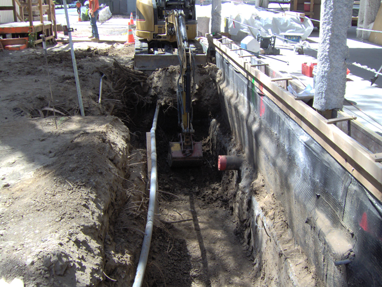
Archaeological excavation is destructive in nature (Renfrew and Bahn (2000)). Anytime artifacts or features are exposed or removed from their location, the surrounding matrix, which may have been the product of hundreds or thousands of years of soil deposition, is irrevocably destroyed. In a controlled excavation, archaeologists attempt to mitigate that destruction by using systematic and scientific procedures during excavation to maximize the amount of data that is collected. In a construction environment, an archaeologist's ability to carry out similar data collection techniques is hindered while at the same time potential site destruction is greater due to the use of heavy machinery. Given the inability to perform detailed analysis while construction related ground disturbance is underway, one of the most valuable types of data a field technician can collect is provenience information. On construction projects, workers are often focused on completing the job as quickly as possible under a fixed schedule. Any interruption to the work flow is considered a financial loss. Additionally, the construction environment itself can interfere with an archaeologist's ability to record data. Ground disturbance activities, such as backhoe trenching, can take place on busy streets and/or up against buildings or retaining walls. These considerations necessitate the establishment of methods that are both efficient and produce valuable data. Another serious problem that can impact the overall quality and consistency
of monitoring on a long-term construction site is the difficulty of
recording and maintaining site location information in a readily accessible
form over the course of months or years. This problem is compounded
by a relatively high turn-over rate amongst archaeological field technicians
and the inconsistency their various personal techniques can produce.
In order to fully take advantage of the benefits of using GIS throughout a project, data collection techniques that are conducive to GIS mapping and that meet the project's goals must be established at the outset. This not only facilitates the input of data into GIS software, but also insures consistent data recording throughout the project's lifecycle. Note: Specific research regarding the use of GIS
to aid in archaeological monitoring appears to be non-existent. Published
articles on GIS in relation to archaeology primarily deals with Site
Probability Modeling and on-site mapping techniques in remote parts
of the world (see Appendix
A). |
| Methods |
|
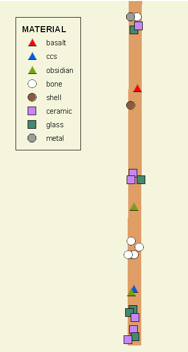
Artifact and trench locations were formulated to realistically simulate construction activities related to utility installations (water, sewer, and electrical lines) within one city block. Twenty-five artifact locations were collected via standard measuring tape and a Garmin Etrex Vista HCx handheld GPS unit. The method for manually recording artifact and trench locations was chosen based on the ability to input them into ArcView 9.2. The x and y data was collected by measuring off the streets and curbs (i.e. 24 ft south of Lillard, 7 feet west of Drummond east curb). By basing the measurements off of the streets and curb, it was possible to ascertain coordinates in ArcMap by measuring off of the curb shapefile while in an editing session. Immediately after each artifact location was recorded on paper, the same location was recorded as a waypoint with the handheld GPS unit. This was for comparative analysis of locational accuracy and data acquisition time. The waypoints were later exported into point shapefiles through the DNRGarmin GPS software utility. Additional artifact locations were created in a shapefile with basic descriptive attributes (Tracking Number, Period, Material, Depth, and Date). |
| Results |
| The twenty-five sample artifact locations required
approximately thirty seconds to one minute to measure and record
the x,y location information. Adding the artifact locations as points in ArcMap and entering basic attribute information required approximately 50 minutes of input time, including the creation of a trench polygon.
The twenty-five sample artifact locations recorded with the handheld GPS unit required five seconds or less to create each waypoint with the GPS at hand and turned on. It took approximately forty seconds to create a waypoint if the GPS needed to be turned on first and acquire satellites. Again, this time does not include the collection of depth measurement, artifact assessment, artifact collection, and additional notes. Adding the artifact locations as points in ArcMap
using the DNRGarmin utility and entering basic attribute information
required approximately ten minutes. |
| Analysis and Conclusions |
| Both recording techniques offer advantages and disadvantages. The overall data acquisition time from finding an artifact to having it's provenience and attribute information entered into ArcMap is far longer with manual recording than with the use of the GPS. However, a far better representation of the x, y data is achieved using the manual coordinates. The poor provenience data offered by the GPS could be acceptable in certain situations. Monitoring on a construction site can be considered similar (or identical to) Phase I and II archaeological investigations. Both Phase I and Phase II investigations are primarily concerned with the identification and evaluation of sites (Trader, 2008). Often times, GPS is the primary tool used to record locational information of sites and isolated artifacts during pedestrian survey and test units out in the field. Under these conditions, the +/- 3 meter accuracy offered by consumer grade GPS units is acceptable. Phase III investigations are more precise and comprehensive excavations to maximize data recovery. It requires measurements off of survey datums to achieve the best provenience information possible. Under these conditions, GPS can not provide an acceptable level of accuracy. However, if a site determined to be significant enough for Phase III investigations was discovered during archaeological monitoring, further ground disturbance by construction crews would be halted so that excavation could occur and the GPS information would not be necessary. Given a GPS unit's ability to rapidly acquire x, y data and input it into ArcMap, it would seem to be the most advantageous method for collecting location information while monitoring. Unfortunately, other factors would need to be considered such as the cost to equip field technicians with GPS units, the dependence upon battery power, and the environment that the monitoring is being conducted in. An urban environment might require a higher than normal level of provenience information so that any costs to later investigations based on archaeological finds can be accurately evaluated. When saw-cutting costs and the proximity to buried utilities are important considerations, +/- three meters is not a realistic level of positional accuracy. However, in a more rural setting, such as during the installation of utility lines across wide areas of land, GPS would probably suffice.
At the completion of a project, GIS provides the ability to conduct more detailed analysis of artifacts and features through symbologies, summaries, and classification. Maps created in ArcView can visually convey artifact locations, densities, types, and depth. This information can quickly and easily be used as a tool to aid in the creation of final reports, charts, and maps for clients and the archaeological community. Although implementing the GIS component of a construction monitoring project would be an added expense, it's clear that the benefits it provides for maintaining data consistency, facilitating quality project management, and conducting more indepth and efficient final analysis more than make up for extra costs. |
References |
|
Renfrew, Colin and Bahn, Paul. Archaeology: Theories, Methods, and Practice. London: Thames and Hudson, 2000: City of Davis. "Data - Mapping and Geographic Information Systems." [Online] Q16.tif, 2005; curb.shp, April 5th, 2004. <http://www.city.davis.ca.us/gis/data.cfm> Trader, Patrick. Wilson, Joanna ed. "Guidelines for Phase I, II, and II Archaeological Investigations and Technical Report Preparation." West Virginia Division of Culture and History, 2008. [Online] <http://www.wvculture.org/shpo/techreportguide/guidelines.html> |
Appendix A |
|
Other Archaeological Sources Related to GIS: Westcott, Konnie L. and R. Joe Brandon, ed. Practical Applications of GIS for Archaeologists: A Predictive Modeling Kit. London: Taylor & Francis, 2000. Hayakawa, Yuichi S., et al. "Rapid On-site Topographic Mapping with a Handheld Laser Range Finder for a Geoarchaeological Survey in Syria." Geographical Research 45 (March 2007) : 95-104. |
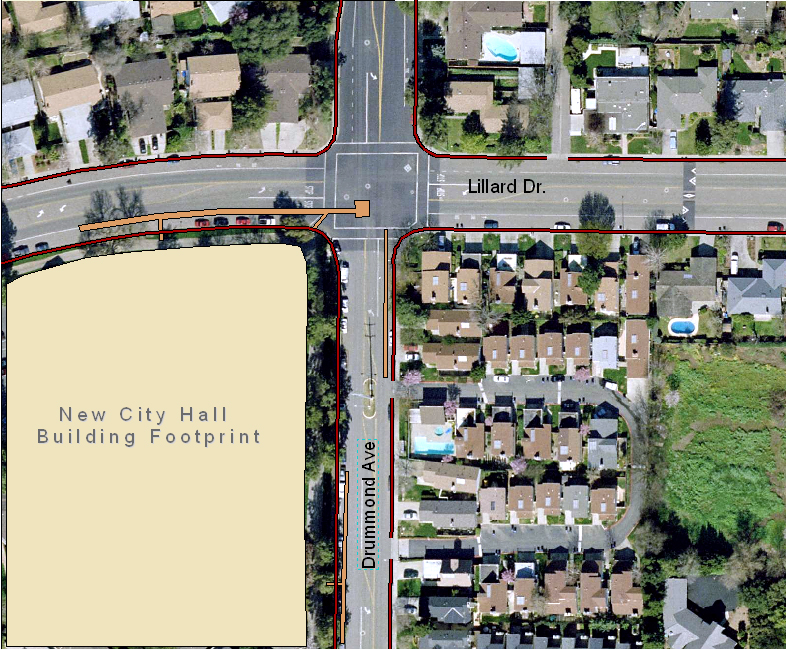 Given the ethical restrictions regarding archaeological site locations
and company confidentiality, a mock construction site was created
in Davis, CA in an easily accessible location for the purpose of
this exercise.
Given the ethical restrictions regarding archaeological site locations
and company confidentiality, a mock construction site was created
in Davis, CA in an easily accessible location for the purpose of
this exercise. 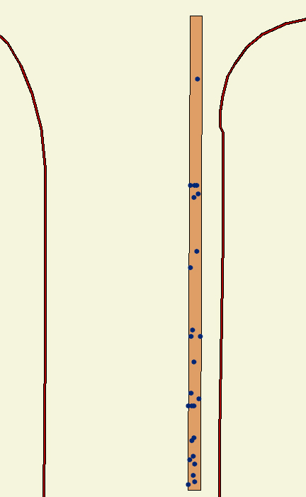 Manual Location Recording
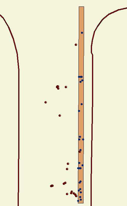 GPS
Location Recording
GPS
Location Recording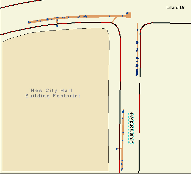
 Once artifacts are plotted in the GIS software, it allows for quick
access to a large amount of easily accessible information and provides
the ability to conduct site analysis while the project is underway.
Areas of special concern can quickly be identified and preliminary
hypothesis' regarding specific site activities can begin to be formulated
by using simple queries of the known information. Any project or
field directors new to the project can familiarize themselves quickly
with the site and its discoveries without the need to sit down and
sift through multiple binders of field notes. Also, the act of entering
artifact information into a GIS on a daily or weekly basis provides
an additional level of checks to insure that provenience information
is collected in an accurate and consistent way. If GIS is used throughout
the course of a construction project, archaeologists can better
manage and synthesize their data as it is being collected.
Once artifacts are plotted in the GIS software, it allows for quick
access to a large amount of easily accessible information and provides
the ability to conduct site analysis while the project is underway.
Areas of special concern can quickly be identified and preliminary
hypothesis' regarding specific site activities can begin to be formulated
by using simple queries of the known information. Any project or
field directors new to the project can familiarize themselves quickly
with the site and its discoveries without the need to sit down and
sift through multiple binders of field notes. Also, the act of entering
artifact information into a GIS on a daily or weekly basis provides
an additional level of checks to insure that provenience information
is collected in an accurate and consistent way. If GIS is used throughout
the course of a construction project, archaeologists can better
manage and synthesize their data as it is being collected.